Home Marine Electronics & Navigation Instruments Marine Navigation Charts & Software
Waterproof Charts - Pacific Northwest Region
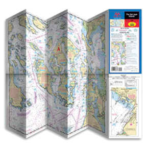
Waterproof Charts - Pacific Northwest Region
Waterproof Charts - Pacific Northwest Region, Puget Sound
SKU: 128600 Item ID: MPT 100
Description
Maptech only uses high-quality, waterproof, synthetic paper for their charts.
• Waypoints for major buoys and channels
• Pre-plotted courses and distances
• Public boat launch locations
• State park information
• Most charts have insets for more detail in popular areas
Specifications
MFG #:100
| TitlePuget Sound
Scale
1:106,600
Title
Puget Sound
Warning
This item may be known to the State of California to cause cancer, birth defects, or other reproductive harm.
Barcodes
9780743608800
978074360880
9780743612029
978074360880
9780743612029
Product Options
| Selected | SKU # | MFG # | Availability | Title | Price | Quantity | |
|---|---|---|---|---|---|---|---|
| SKU #: 128600 | MFG #: 100 | 19 In Stock Ships immediately | Puget Sound | $24.95 | |||
| SKU #: 128601 | MFG #: 101 | 11 In Stock Ships immediately | Seattle and Lake Washington | $24.95 | |||
| SKU #: 129861 | MFG #: 102 | 7 In Stock Ships immediately | Oak Bay to Commencement Bay | $24.95 | |||
| SKU #: 129862 | MFG #: 103 | 5 In Stock Ships immediately | Cape Flattery to Whidbey Island | $24.95 | |||
| SKU #: 128602 | MFG #: 104 | Special Order Only | The San Juan Islands | $24.95 | |||
| SKU #: 129864 | MFG #: 107 | 3 In Stock Ships immediately | Bellingham to Skagit Bay | $24.95 |