


Description
Getting oriented...
♦ Garmin's 84xx Series of the touchscreen GPSMAP features Worldwide Basemap – a non-detailed map for general reference. Available in six display sizes.
♦ Garmin's 86xx Series of the touchscreen GPSMAP features BlueChart® g3 – detailed charts for US coastal waters and LakeVü™ g3 – detailed mapping for lakes in the US. Available in three display sizes.
♦ An xsv suffix indicates the addition of integral sonar capability (requires a separate sonar transducer).
GPSMAP 8410 features –
• 10” full HD In-Plane Switching touchscreen display
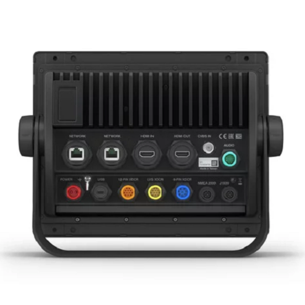
• Fully network capable with NMEA 2000® connectivity and the Garmin Marine Network
• Includes ANT® technology and Wi-Fi® networking
• Garmin SailAssist™ feature provides critical sailing data and displays pre-race guidance for racers
• SmartMode™ station controls enable quick, one-touch access to the information you need
• Radar and Sonar compatible; supports AIS and DSC safety protocols
Serious cruisers, sailors and sail racers demand serious equipment. The easy-to-use, easy-to-install GPSMAP 8410 chartplotter delivers Multi-Function Display performance in a combo-size package.
It features a 10” full HD IPS touchscreen display for wider viewing angles, superior clarity and sunlight readability, even with polarized sunglasses. Multiple displays can be flat mounted edge-to-edge to create a sleek glass helm look, or can be mounted flush.
The GPSMAP 8410 also provides standard USB touch output for use as a touchscreen monitor for Windows® and Mac® operating systems.
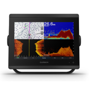
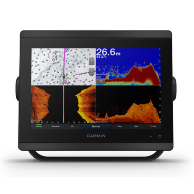
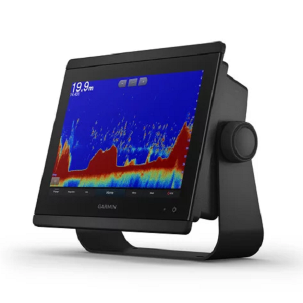
Built-in Sonar Capabilities
Right out of the box, you have access to some amazing sonar capabilities; all you have to add are transducers. Comes with built-in Garmin 1 kW CHIRP sonar, CHIRP ClearVü and CHIRP SideVü scanning sonar. It even supports Panoptix all-seeing sonar, premium Garmin sonar modules and a wide range of transducers (sold separately).
Networked combos can share their internal sonar with any other device on the network. You can also choose what information is overlaid on the sonar screen; for example, radar, time of day or GPS speed.
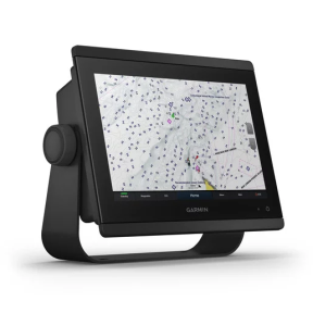
Pre-Loaded Cartography
Garmin's basemaps are the simplest maps available on a Garmin unit and are typically included with the unit from the time of purchase. They have one of several types of data depending on the purpose of the GPS – in this case, marine data. Basemaps are included with all "GPS" models.
Garmin's Worldwide Marine Basemap provides worldwide shaded relief coverage, including oceans, seas, lakes greater than 5 sq miles and rivers down to 100 ft wide.
It includes international and state political boundaries, and displays worldwide principal cities with population greater than 20K, major interstates and/or principal highways, political boundaries (state and international borders), large airports, and time zone information
Worldwide Marine Basemap also shows NOAA Weather Polygons for the U.S.
Build Your Marine System
NMEA 2000 networking and the Garmin Marine Network allow you to easily build your full marine electronics suite — from radar and autopilots to cameras, instruments and forward-looking sonar — controlled from your chartplotter and shared across multiple screens.
In addition, Garmin's exclusive OneHelm™ system coordinates many third-party manufactured onboard marine products to bring full control of systems — such as digital switching, lighting, stabilization and more — conveniently to your chartplotter screen.
Full Connectivity
The GPSMAP 8410 chartplotter has a premium-performance processor that enables fast map drawing, superior networking, video distribution and more.
Built-in Wi-Fi technology lets you pair with the free ActiveCaptain® app for access to OneChart™, smart notifications when paired with a compatible smartphone, Garmin Quickdraw™ community data and more.
You can also control video streaming from Garmin's GC™ 100 wireless camera and VIRB® action cameras.
In addition, built-in ANT wireless technology connects you directly to Garmin's quatix® marine watch, gWind™ Wireless 2 transducer and wireless remote controls.
SmartMode Station Controls
Networked sonar, radar, cameras, media and digital switching can be independent or incorporated into SmartMode station controls. With SmartMode, everything is designed to give you quick, one-touch access to the information you need to ease high-stress situations such as docking.
The Best of Garmin with the Best of Navionics®
For the most detailed, clear and concise charts and maps, GPSMAP 8410 includes expandable memory for accessory map purchases such as BlueChart® g3 or the upgraded, feature-rich BlueChart® g3 Vision, as well as Canadian charts, featuring Navionics data. Refer to the Garmin website GPSMAP 8410 product entry for the full selection of available charts and maps.
The charts and maps also include Garmin's Auto Guidance technology, which shows a suggested route to a destination, based on your boat’s specifications. (Note – Auto Guidance is not meant for actual navigatigation purposes.)
Has provision for two MicroSD cards, stores 5000 waypoints and 100 routes (up to 250 waypoints each). Track log can support 50,000 waypoints and 50 saved tracks.
Optional Remote Control
You don’t have to stand for hours at the helm. The optional easy-to-use GRID™ 20 remote input device provides intuitive remote access and control of your entire Garmin marine system. It features a 360-degree joystick with a rotary knob and push-to-select button for easy chartplotter menu/setting navigation and fine control, even in the worst conditions.
Special Sailing Features
To help you make informed decisions, the Garmin SailAssist feature provides critical data displays and pre-race guidance to help you gain a competitive edge.
Other sailing features include laylines, enhanced wind rose, heading and course-over-ground lines, true wind data fields and tide/current/time slider.
Gauge displays provide need-to-know information at a glance, including true and apparent wind angle, set and drift, true or apparent wind speed, horizontal or vertical graphs and a data bar with customizable fields.
The Ultimate Connected Boating App
Download the ActiveCaptain app to your smartphone or tablet to manage your marine experience from anywhere — from trip planning and pre-fishing to updating software and purchasing maps.