Garmin Navigation and Marine Electronics at Fisheries Supply
This page is meant to help boaters choose and integrate Garmin marine electronics available from Fisheries Supply for navigation, safety, and fish-finding on recreational and commercial boats.
At A Glance
- Comprehensive selection of Garmin chartplotters, fishfinders, radar, and autopilots.
- NMEA 2000 networking for plug-and-play integration between onboard systems.
- Knowledgeable Fisheries Supply staff to help design complete electronics packages.
- Large in-stock inventory with domestic and international shipping options.
Why Choose Garmin Marine Electronics from Fisheries Supply
Fisheries Supply offers a wide range of Garmin electronics to help boat owners navigate, stay safe, and communicate with confidence. Garmin is a leading provider of marine navigation systems, sonar, and connectivity solutions for both recreational and commercial boats.
With thousands of marine products in stock and close relationships with premium marine brands, Fisheries Supply supports customers across the United States and worldwide with same-day shipping on many orders, freight options, and free shipping thresholds for qualifying orders.
From chartplotters and fishfinders to radar systems and autopilots, Garmin provides a cohesive ecosystem of premium marine electronics that can be installed as standalone units or networked together to share data throughout the boat.
Garmin Chartplotters, Fishfinders, and Transducers
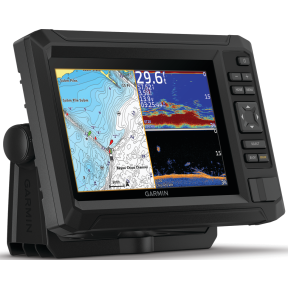
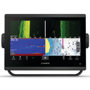
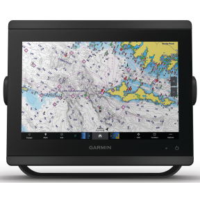
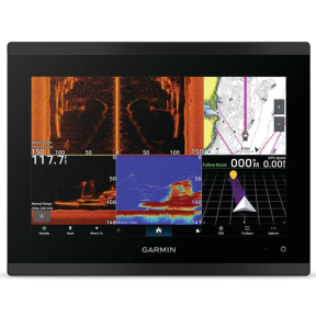
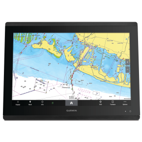
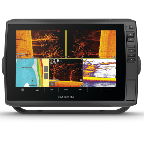
Chartplotters for Clear, Reliable Navigation: Garmin’s state-of-the-art chartplotters combine high-resolution displays, fast GPS positioning, and powerful processing to give captains a clear picture of where they are and what lies ahead. Models such as the GPSMAP 8412 feature a preloaded Worldwide Basemap, built-in sonar options, and wireless connectivity, making them suitable for both coastal cruising and offshore passagemaking.Fishfinders and Advanced Sonar: For anglers, Garmin fishfinders and scanning sonars provide detailed views of fish, bait schools, and bottom structure. These systems help fishermen target potentially productive water efficiently.
Transducers for Accurate Underwater Data: Pairing the right transducer with your chartplotter or fishfinder is critical for accurate depth and fish readings. High-performance options such as the Six Pin Transom Mount Transducer, model 010-10272-00 are designed to work seamlessly with Garmin sonar platforms for reliable results at a range of speeds.
Autopilots, Radar, and Core Navigation Systems
Garmin Autopilots for Confident Course-Keeping: Garmin autopilots provide precise steering and course guidance, helping reduce helm fatigue and improve fuel efficiency over long runs. Integrated with your chartplotter and sensors, these systems can hold a heading, steer to a waypoint, or follow a route under a range of sea conditions.Garmin Fishfinders and Sonar Modules: Garmin fishfinders use cutting-edge sonar technologies to help locate fish and underwater structures with pinpoint accuracy. When paired with appropriate transducers, they deliver the detail needed for jigging, trolling, and bottom fishing alike.
Garmin Chartplotters for Detailed Mapping: Garmin chartplotters serve as the central display for many onboard systems, combining detailed mapping, AIS overlays, radar, sonar, and engine information into a single, easy-to-read interface.
Garmin Radar for Situational Awareness: Garmin radars add an essential layer of situational awareness in fog, at night, and in busy waterways. Modern solid-state radar domes and open arrays offer fast target acquisition, low power draw, and integration with chartplotter overlays.
Networking, Communication, and Connectivity
NMEA 2000 and Analog Integration: Garmin marine electronics are designed to work on NMEA 2000, a marine plug-and-play communications standard based on CAN bus technology that allows sensors, displays, and control units from multiple manufacturers to share data over a single backbone cable. This simplifies installation and troubleshooting compared with legacy point-to-point wiring.A Garmin NMEA 2000 starter kit or analog-to-NMEA 2000 adapter makes it straightforward to bring legacy instruments and engines onto the network so that data can be displayed on modern chartplotters and multifunction displays
Onboard Connectivity: Bluetooth and Mobile Apps: Many Garmin systems support Bluetooth connectivity and Wi-Fi, enabling you to connect compatible smartphones and tablets for software updates, chart downloads, and remote control of selected functions.
The free ActiveCaptain app creates a powerful connection between your mobile device and compatible Garmin chartplotters, charts, and community data, allowing you to manage many aspects of your marine experience from nearly anywhere. This complements PC-based tools like Garmin Express for software and map updates.
Personalized Garmin Electronics Solutions from Fisheries Supply
Working with Fisheries Supply Staff: Representatives at Fisheries Supply have hands-on experience with Garmin marine products, including built-in GPS receivers, multiple screen sizes, and a variety of advanced scanning sonar options. They can help match equipment to the way you use your boat, whether you run a commercial workboat, a cruising sailboat, or a trailerable fishing rig.While Garmin systems are designed for intuitive use, correct installation still matters for safety and reliability and should follow sound marine electrical practices and any applicable standards. On more complex projects, many owners coordinate with a qualified marine technician or yard that is familiar with modern NMEA 2000 networks and relevant best practices.
Designing a Complete Garmin Package: The team can help you assemble a package of Garmin marine electronics tailored to your boat, taking into account helm layout, existing wiring, power budget, and long-term upgrade plans.Frequently Asked Questions
How do I update the software on my Garmin marine instruments?
To update your device's software, download and install Garmin Express on your computer. Connect your device via USB, and Garmin Express will guide you through the update process. You can also use the ActiveCaptain app for compatible systems.
What should I do if my Garmin marine device won't acquire a GPS signal?
Ensure the device has a clear view of the sky, free from obstructions. If issues persist, resetting the device or updating its software may help restore GPS reception.
How can I purchase and install additional maps on my Garmin marine device?
Additional maps can be purchased through Garmin's website or authorized dealers. Once acquired, use Garmin Express to install them onto your device or follow the on-screen instructions in the ActiveCaptain app when supported.