
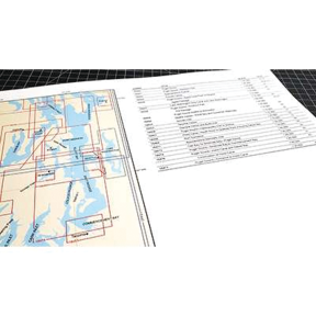


- Large format (12x18")
- 46 page booklet
- Printed on high-quality paper
Description
• 36 reduced-scale complete NOAA charts of the Puget Sound area.
• Spiral bound in a large format (12x18") 46 page booklet.
• Printed on high-quality paper and updated regularly.
• Not recommended for navigation, but handy for reference and use aboard small craft.
• ISBN: 9781951116217
• Includes the following NOAA charts: 18400 18421 18424 18427 18428 18429 18430 18431 18432 18433 18434 18440 18441 18443 18444 18446 18447 18448 18449 18450 18452 18453 18456 18457 18458 18460 18464 18465 18468 18471 18473 18474 18476 18477 18480 18484 18502 18504 18521
This chart atlas covers all of the popular boating areas across the United States. It includes all of the full sized NOAA charts from each area and scale them down to fit the 12 x 18” format. Spiral binding makes it easy to use these atlases when reviewing an area. We use only high-quality coated paper and print on state-of-the-art printers. We laminate each cover for durability. Each atlas begins with key to the charts and a table of contents. Charts are arranged by chart number. In some cases we split a single chart into a two-page spread, but most charts are presented one per-page. Each atlas is updated at intervals throughout the year. These books are designed as a useful reference and are not recommended for navigation purposes. However, these atlases are a great value to boaters and armchair sailors alike.
Specifications
This product can expose you to chemicals which are known to the State of California to cause cancer, birth defects or other reproductive harm.
www.P65Warnings.ca.gov